We have been planning this trip for a year now. Majlis Al Jinn was on my list since I arrived in Oman. It is the 2nd largest cave chamber in the world. Three times I tried but couldn’t make it. It was car trouble twice and once the road was washed by sudden rains.
So this time we planned to avoid these things. There were no reported rains in past few weeks and my car was a no-nonsense Nissan and not a Jeep. We went up from Qalhat, an ancient town on Arabian Sea coast. It’s popular for Bibi Mariam’s tomb. Tomb area was closed because of excavations so no visits. This road is the least steep of the three access routes to the Selmah plateau, the place where all the action awaits. Selmah is just one of the topographic features in Eastern Hajar, but most people from Muscat know the area by this name.
First waypoint on our trip was Umq Bir. Umq in arabic means deep or depth. Bir is the name of the village. Umq Bir is the old village deep in the valley. Like many other mountain villages in Oman, hidden from the harsh sun and close to a water source. The new villages are built closer to roads because now piped water can be taken anywhere, it’s the roads that are difficult to build. Road from Bir to Umq Bir is 4 km narrow steep track. Last time this bit was washed by recent rains. This time we were prepared to walk but luckily road was intact. Now we had been driving on fair dirt tracks for more than an hour so I was warmed up for the tough drive. After half a dozen switchbacks you arrive at a spot with no road ahead and enough space to park. In front of you are massive cliffs of Wadi Tiwi. Umq Bir is also the source of Wadi Tiwi.
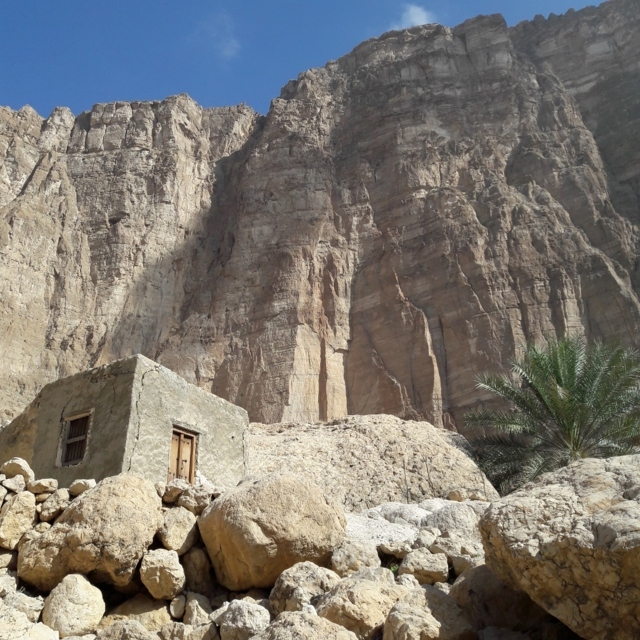
From the end of the road a visible trail goes to a huge flat rock floor below. There are several large rocks resting on this huge rock. The landscape seems like some giants been playing dice here. A patch of green fields on barren rock appeared as if transported from elsewhere completing the giant fantasy. We met 2 old men in the village doing some chores. The houses were mostly single rooms. Some were built under big rocks which ensured shade all day and of course solid waterproof natural roof. We spent an hour in this mysterious landscape, ate a sandwich overlooking the palms and walked back up to the car. Driving back was a bit more thrilling as a baba drove head on in a pickup. Normally back home the guy coming downhill goes back in tight spots but baba was not cooperating. I went back down to the last switchback where baba could pass, said salaam and continued uphill.
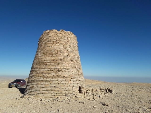
Next on our map was the beehive tombs. Irina had never seen the ones up here. I had passed by these on a previous visit when the roads were washed. The tombs are called Jaylah tombs after a nearby village. I don’t know why these are called Jaylah tombs when there are several other bigger villages closer to the tombs. Perhaps it was the people from Jaylah who built them! They certainly might have, as we found next day that they built a beautiful falaj which is now listed as UNESCO heritage. We drove to the tombs with an eye for a camping spot on this Mars like terrain. It was late noon. We reached the tombs around 5 pm. We had chosen a camping spot before arriving here but a thought passed by our mind to camp next to the tombs. It vanished when we stepped out of the car. The wind was biting cold and quite strong. So we focused on the tombs and decided to return to the camping place we had seen before. There are at least half a dozen of them on this very flat area. The road passes through the middle of the site. The more intact ones are to the north of the road. Some are just bare platforms broken down by weather over time. Or maybe earthquakes and humans. The intact ones are about 5 meter tall. All have a 3 foot high entrance to the east. Their purpose was debatable but now archaeologists have agreed that these are burial tombs. The bodies might have been removed by people or animals but they were there at some point. You can see the Arabian Sea about 1700 m below to the north. It must have been some site when villagers gathered around these tombs to say farewell to the most loved ones.
We returned to the camping spot. We drove on a barely visible steep track just to explore. It took us to a telecom antenna. We could see another village down to the south from here. The mountain profiles with the setting sun were amazing. Down at the campsite we cooked Maggie noodles and later some tea. It was around 10C but no wind. Much pleasant than our last camping in Jebel Akhdar.
Next morning we drove towards the tombs again. We took some morning pics of tombs with clear sky blue background. We explored another group of tombs on top of a hill. This was a superb viewpoint. Only one of these 4 tombs was intact. They say these are up to 6000 years old. People continuously lived in this area but no one knows for sure how and why these were built, like many other historical structures. Either the people who originally lived here, moved, or they were killed by invading tribes who didn’t bother with the customs of the previous inhabitants. Or there was simply no interest in passing information to next generations, no written records, no scripts. This makes me even more eager to pen it down.
Next waypoint, Jaylah, the secret village which is on UNESCO maps but still very remote. It has managed to stay away from Google maps as well though the tombs are marked. A little more than 10 km of tough roads and we are in Jaylah. The access was similar to Umq Bir. This road was a few degrees steeper. The village was still few hundred meters away but we decided to park in a spacious wadi crossing. Later we found that it was a good decision. As we entered the village boundary still on the road a lady greeted us. Her Arabic was difficult to understand even for Irina. I was just happy that she was not offended by our presence. She came forward and shook hands with us. Surprisingly with me too! Rough heavy worker hands as if forged in a furnace. She invited us for kahwa but we politely refused. We walked towards the main village and farms. The houses were quite big for the remoteness of this place. Seems UNESCO name has brought some welcome prosperity. Three village kids followed us from where we met the lady, Salima Ahmed and Masood. After some time they were in front of us and showed us the stairs to the falaj. We followed the kids, they brought us to a cement tank which collects the falaj waters. The flow was mediocre but seems enough for this small population.
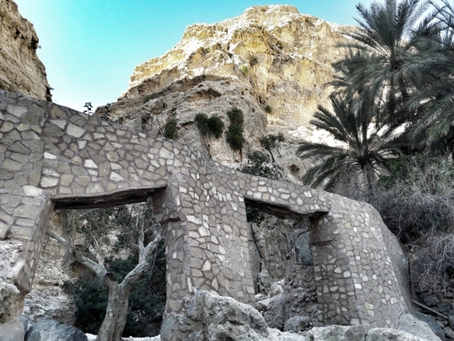
Now Salima asked me if I wanted to walk further to the source. I said yes and she walked in front. Masood and Ahmed the eldest of the three, followed. Salima seemed most enterprising to sell me the falaj. The path went through the opposite slope. I could see the tank and falaj on the limestone wall where we were standing a while back. To build it about 4000 years back must have been a tremendous feat. Irina was still there. This was too exposed for her liking. We walked few hundred meters on the side of the canyon. The canyon turned into a cave chamber with an open roof. At the end of the chamber was the falaj. It came out of a cave, then it was exposed for a few meters and then again entered a cave. Further the falaj emerged from this cave on the right wall of the canyon and continued to the cement tank. Ahmed said it is possible to go into the source cave few hundred meters with a torch light. On the way back kids were curious about their wages. I handed Salima 5 Rials and asked her to share with others. Kids were happy. They would spend it on candies perhaps, 2 hrs away in Tiwi when they go to school on Sunday. This falaj also constitutes a bridge. The bridge is renovated with cement. The old bridge made of stones and mud must have been an imposing structure for its time. Back in the village I was surprised to see Pakistani labourers doing farm work. I wasn’t expecting remote Jaylah locals to hire foreign labour. Anyways, Pakistanis have a job and Jaylans have more time to stare at limestone.
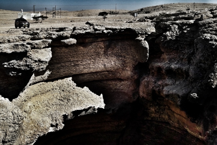
Now we start on the route back to coast. But before that we wanted to see Majlis Al Jinn, the gathering of genies. It is the second largest cave chamber in the world. From Jaylah we followed GPS and arrived at a tri-junction. From the tri-junction the two roads run parallel on the two sides of wadi fins. The road on the left goes to Majlis Al Jinn. Last time when i was here this road was washed at the start. We were forced to skip Majlis Al Jinn and drive down to Muscat-Sur highway on the right side road. This time the patch was barely drivable. At one point i thought this is not the road but then suddenly we came out of the wadi and I could see few hundred yards of very bad road running up a hill side. Once on top this road was nicely graded. We reached Majlis Al Jinn. It is not a very large cavity and in the afternoon most of it was dark. There is a portacabin nearby with an AC fitted. Government probably thought of selling tickets to the cave. But it seems that it didn’t work. Probably no one wanted to sit in the cabin and wait for customers in this amazing countryside. Few pics and we were on the road. The road from here winds down steeply to join the Muscat-Sur highway. Slow careful low gear crawl and in 30 mins we were down.
From the asphalt road we looked back at the steep sides of Selmah. This was a memorable trip. Lovely landscape and good vibes from locals. We covered 3 major and very remote landmarks in Oman, the Beehive tombs, UNESCO falaj in Jaylah and Majlis Al Jinn. And Umq Bir was a bonus.
